Severe storms are expected across much of the East Coast this Monday
Damaging wind gusts, flash flooding, and even tornadoes can cause serious problems from Florida to New York.
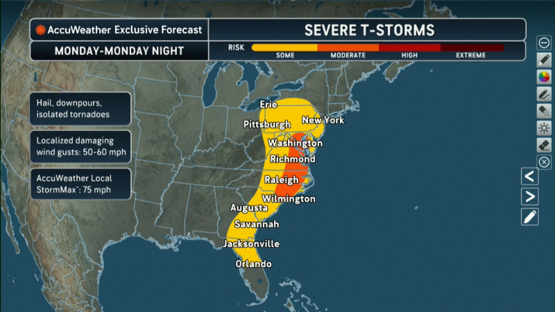
Tens of millions of Americans were under severe weather warnings on March 16 as a winter storm threatened to bury the Great Lakes region in more snow and mid-Atlantic states braced for thunderstorms that could bring damaging winds and tornadoes.
According to the National Weather Service, the greatest risk extends to the eastern half of the United States from central Florida to New York, while the most severe risk of severe weather is concentrated from Georgia to Maryland.
Forecasters said the powerful thunderstorms could bring hurricane-force winds, heavy rain and tornadoes to much of the Mid-Atlantic region, including Washington, D.C., Virginia and North Carolina. The National Weather Service has issued a “moderate risk” rating of 4 out of 5 from the Blue Ridge Mountains to the Chesapeake Bay.
Forecasters warned that the storm could disrupt flights, uproot trees and cause power outages across the region. School districts in several states have canceled classes or adjusted school hours in the face of bad weather. In Maryland, Governor Wes Moore declared a “state of readiness.”
Meteorologists say the worst of the storm is expected in the afternoon and evening.
The expected storm is associated with a cold front extending east from a strong winter storm that will bring blizzard conditions to the Great Lakes region.
The powerful cyclone is expected to dump an additional 8 to 10 inches of snow in Wisconsin and Michigan, and up to 18 inches in Michigan’s Upper Peninsula, bringing the region’s two-day snowfall total to 2 to 3 feet.
The winter storm left more than 120,000 Michigan homes and businesses without power, according to USA TODAY power outage tracking.
Forecasters expected powerful storms to develop across parts of the Southeast, including states such as Florida, Georgia, Tennessee and Kentucky.
Flash flooding was possible in South Florida, with more than 5 inches of rain falling in parts of the Everglades, the weather service said. Rainfall of 2 to 4 inches per hour is possible through the morning, increasing the risk of flash flooding.
According to the National Weather Service in Louisville, Kentucky, Flaherty, Kentucky, suffered extensive damage overnight, with trees falling on several buildings and downed power lines. Wind gusts of 127 mph were reported in Sevier, Tennessee.

